Programs Admissions Our Work Student Experience About
Programs
Undergraduate Programs Graduate Programs Certificate Programs High School Summer Program
Admissions
Scholarships and Financial Aid Visit Information Sessions
Our Work
Faculty Research Professional Practice Student Work Research Centers & Institutes Research Labs Galleries and Exhibits
Student Experience
Campus to Capitol Mentoring Programs Student Organizations Spaces and Studio Education Abroad Competitions Professional Development Student Resources Alumni
About
People News and Events Accreditation Contact Us Giving
Undergraduate Programs Graduate Programs Certificate Programs High School Summer Program
Scholarships and Financial Aid Visit Information Sessions
Faculty Research Professional Practice Student Work Research Centers & Institutes Research Labs Galleries and Exhibits
Campus to Capitol Mentoring Programs Student Organizations Spaces and Studio Education Abroad Competitions Professional Development Student Resources Alumni
People News and Events Accreditation Contact Us Giving
Event - April 20, 2026

Urban Lacunarity: Multiscale Analysis of Texture Patterns Through Satellite Images

Time: 1 - 3 p.m. | Location: Preinkert Hall Building, Room 1224 (SIRJ Lab Room) + Zoom

Home About News and Events Event Calendar Urban Lacunarity: Multiscale Analysis of Texture Patterns Through Satellite Images
Aerial shot and map of an urban lacunarity, through satellite images

Location: Preinkert Hall Building, Room 1224 (SIRJ Lab Room) + Zoom

This event is open to the UMD and MAPP community.

Dr. Mauro Normando Macêdo Barros Filho
Urban Planner, Associate Professor at the Federal University of Campina Grande (Brazil)


About the workshop:

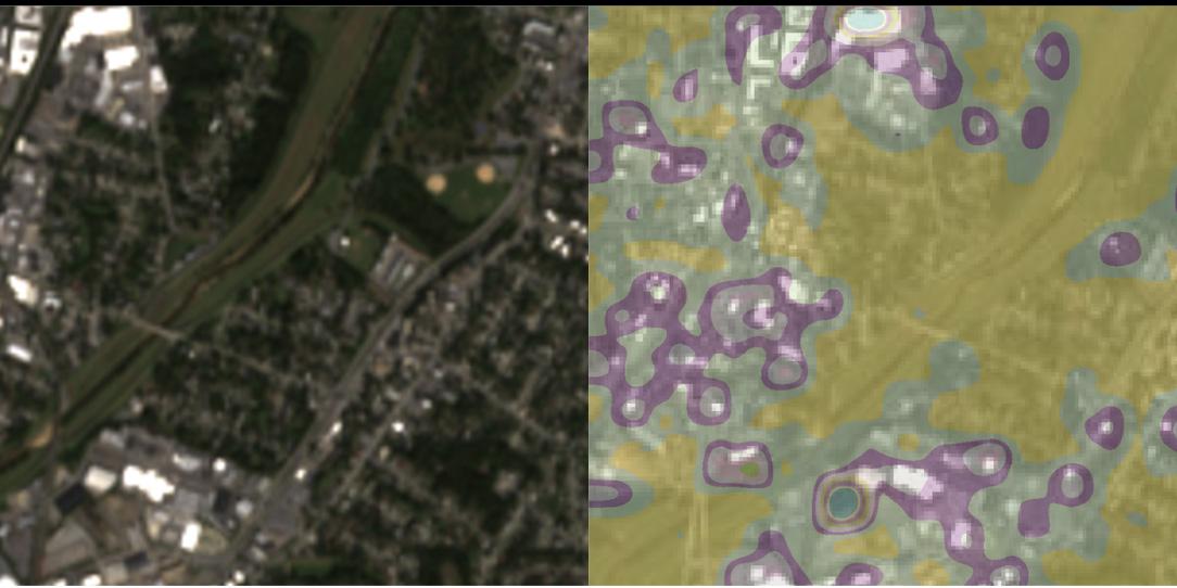
Lacunarity is a property of fractals that helps analyze the distribution of gaps within spatial structures across multiple scales. This workshop will be led by Associate Professor Dr. Mauro Barros Filho from the Federal University of Campina Grande, Brazil, whose extensive research on this topic has been published in books and scientific journals.

The workshop is divided into two parts. The first part introduces the concept of lacunarity, explains how it works, and explores its applications in urban studies. The second part presents the main features and functionalities of LACUNAE, a software tool for analyzing the lacunarity of digital images.

To better understand the contribution of lacunarity to urban morphological analysis, participants will be invited to conduct hands-on experiments using LACUNAE with a satellite image of the community of Edmonston, MD.

Joining Online?

  • Zoom Link
  • Meeting ID: 987 9040 4506
  • Passcode: SIRJ2026
School of Architecture, Planning and Preservation
3835 Campus Drive, College Park, MD 20742
archinfo@umd.edu 301.405.8000