
Innovative mapping tool will help community identify opportunities for development, revitalization
The first Baltimore application of innovative mapping tools, which illustrate and track a variety of economic and social drivers—from vacant housing to job accessiblity—was presented Wednesday night to community members and stakeholders in Southwest Baltimore. Developed in collaboration with Baltimore’s Southwest Partnership (SWP), the tools are the result of a graduate-level urban planning course aimed to help enhance quality of life for Southwest Baltimore residents and to engage development in the area. The course was one of two conducted last fall in Baltimore as part of UMD’s Partnership for Action Learning in Sustainability (PALS) program.
“As a university, we really need to be engaged in Baltimore. It’s the most important city in the state, and has a lot of challenges right now,” said Gerrit Knaap, Director of the National Center for Smart Growth, which runs the PALS program. “We are very excited about this partnership, and hope it’s just the first example of work we can continue to do for the city.”
Tools to Empower a Community
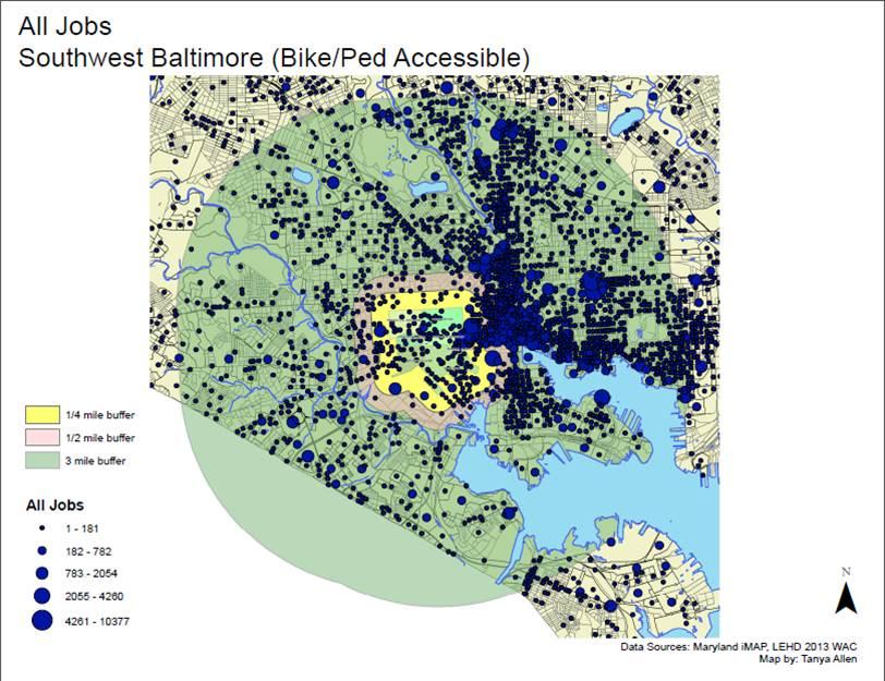
Under the direction of Assistant Professor of Urban Studies Chao Liu, 20 graduate students compiled raw data from the U.S. Census Bureau, Department of Labor, Maryland Department of Planning and other resources, then employed GIS technology to create a series of mapping tools that illustrate trends in crime, housing, safety and street “wellness,” workforce development and job accessibility. While these tools will help the community track everything from crime hotspots to workforce development centers, they can also be overlapped to identify high-need areas and offer possible correlations. One map shared at the forum explored the relationship between street light outages and crime; another noted that, while over 50% of SW residents do not have access to a car, 60% of Baltimore’s highest paying jobs are within walking distance of the neighborhood.
“It’s one thing to throw out statistics about job accessibility, but when you can see it on a map, it becomes quite powerful,” explained Derek Lombardi, a graduate student in the Urban Planning Program. “Armed with this information, the community can better prepare its residents, particularly those about to enter the workforce, for the job market and provide paths to those higher paying jobs.”
The mapping tools were also used to develop several online maps, applications that allow the residents to turn neighborhood snapshots into “living maps” through crowdsourced information by using computers or smartphones. The development of a streetscape tree canopy program, a priority for the SWP, can be tracked and planned through the maps, as can illegal dumping, street repairs and trash removal.
“These are tools we will be able to use well into the future,” said Michael Seipp, Director of the SWP. “To continue to gain funding, we have to show progress. If we have a baseline, we can show that this much commercial activity has happened, or housing renovation statistics that will show what progress we are making as a partnership. What the students are delivering is something we can take and continue to build upon. In essence, it will help the SWP and its seven neighborhoods be more effective and efficient at what we do.”
The genesis of the PALS partnership in Baltimore began when Knaap contacted Seipp, a long-time community advocate, about hosting two courses in Southwest Baltimore, one around real estate development concepts and the other, a GIS course offered by the urban planning program. The results of the real estate development course, which were also presented during the community forum, offer several economically viable, specific development plans for the Hollins Market area and a glimpse of the community’s potential. Under the leadership of Adjunct Professor Robert Kaufman, the students identified trends, weaknesses and indications of what the market will bear to develop feasibility studies and potential models for development. The students’ proposals ran the gamut, from an active, yet affordable, senior housing enclave to a vibrant, mixed-use development that capitalizes on UMD’s BioPark.
“It was incredible experience to work on this project with such a vibrant community,” said MRED graduate Molline Jackson. ““I wanted to offer a proposal that transforms a space to reflect the community needs, while keeping the integrity of its history.”
The Southwest Partnership in Baltimore consists of seven neighborhoods and six anchor institutions, including University of Maryland’s BioPark and University of Maryland Baltimore. Despite a strong community presence, proximity and walkability, the community faces a 30% vacancy rate, crime and blight, challenges not exclusive to Baltimore.
“The challenges seen in Baltimore are the same struggles seen in communities around the country,” said Uri Avin, Director of the PALS program. “What we do in these collaborative relationships could potentially serve as an example for others.”
In the next month, NCSG Research Associate Dan Engleberg, who lives in Baltimore, will install the mapping tools into SWP’s system and help train their staff. The mapping tools are an important starting point for igniting the community’s economic and social engines, explains Seipp, who envisions UMD establishing an urban extension in Baltimore—similar to the agricultural extension of years past—to continue community outreach and assistance.
“There is a need for resources like these to help communities like our turn things around,” said Seipp. “I am hopeful this is just the beginning of our work with the University of Maryland.”