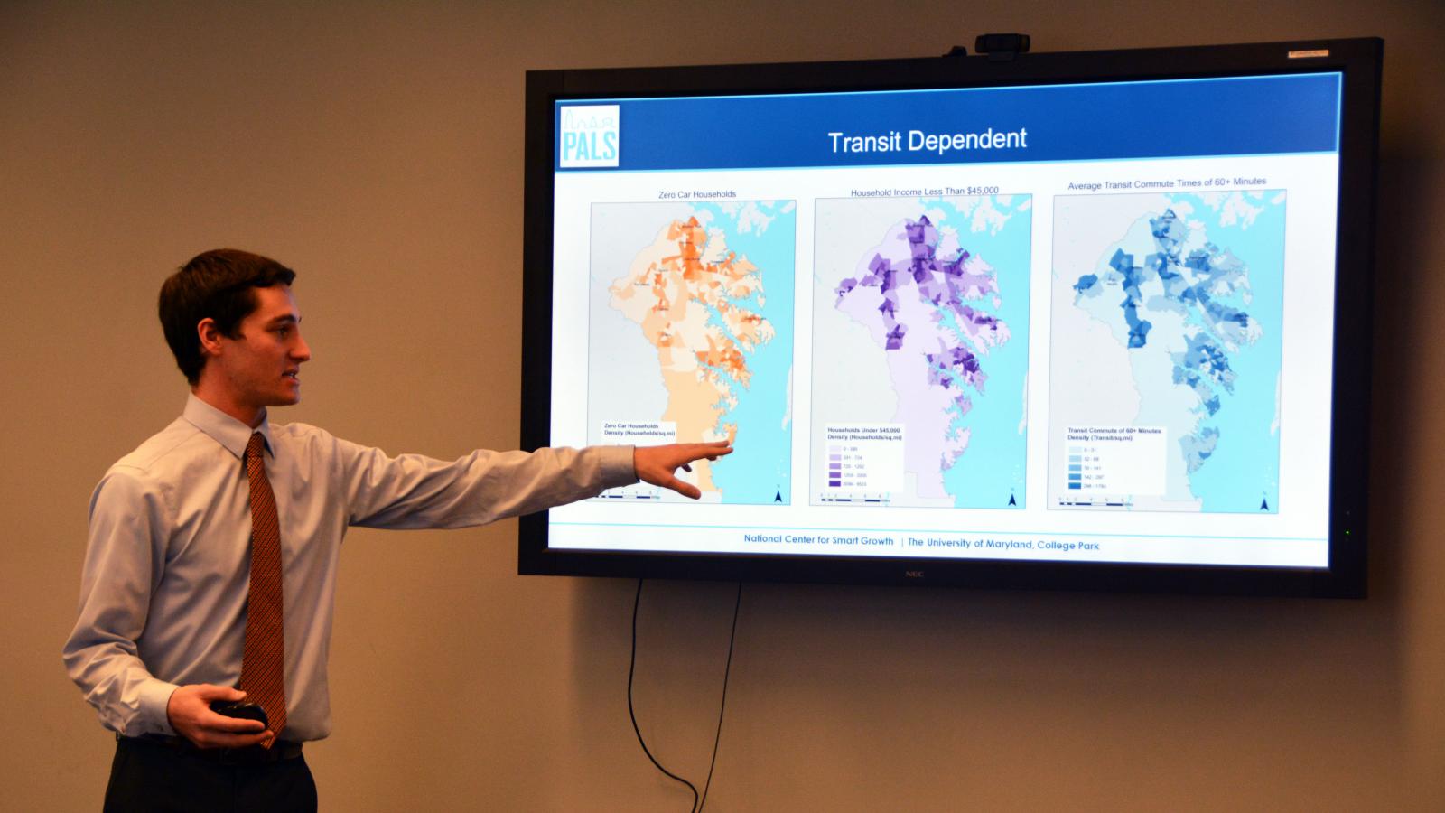
Of the 53,000 low-income workers who live in Anne Arundel County, Md., less than half are within walking distance of a bus stop. That was one of the findings of a study, conducted last fall by graduate students of University of Maryland’s (UMD’s) Urban Planning Program, which examined the correlation between where the county’s most vulnerable workers live, where job opportunities lie and if the two are adequately connected by transit. Conducted as part of UMD’s Partnership for Action Learning in Sustainability (PALS) program, the project was one of a series this year in Anne Arundel County that were overseen by Dr. Chao Liu to help county agencies improve services to residents.
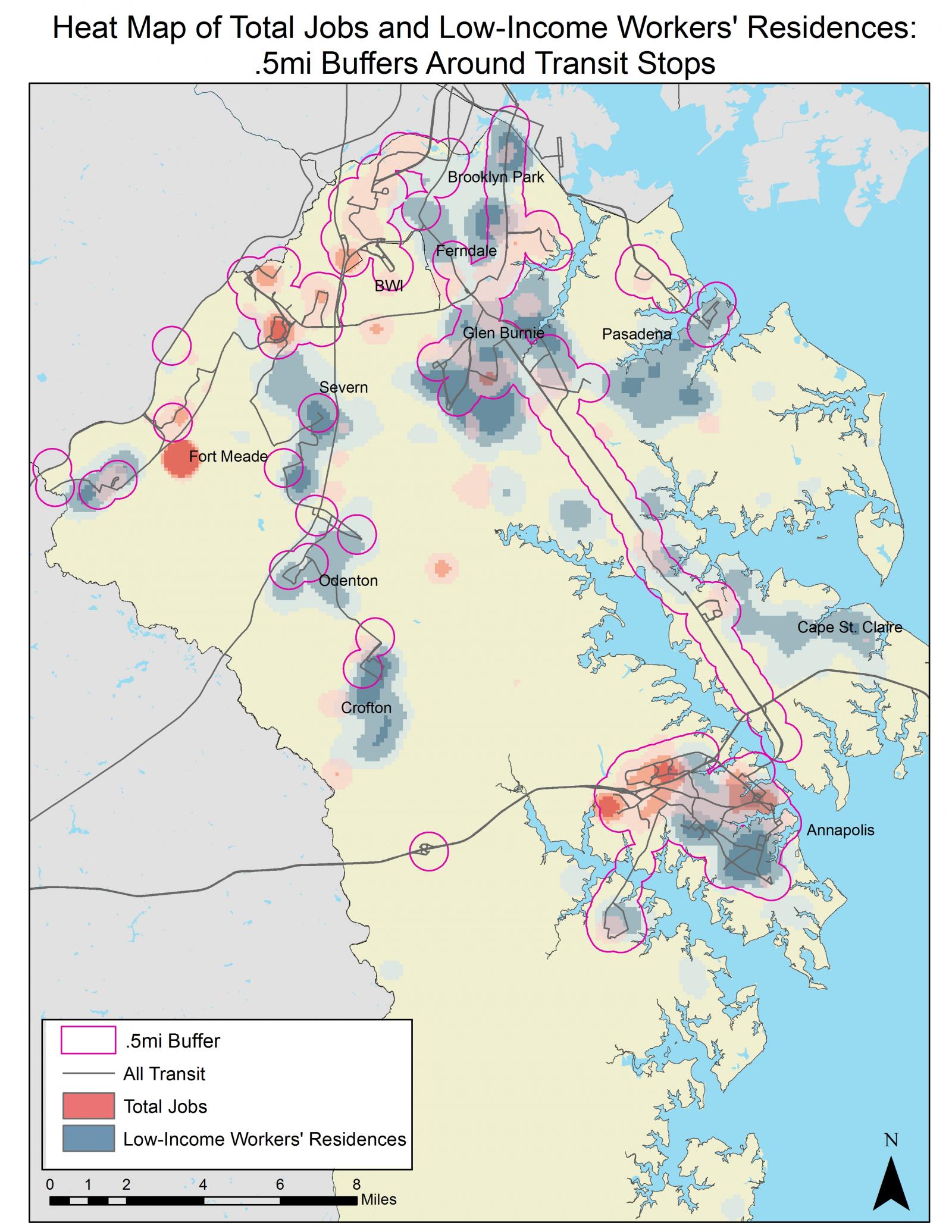
Using a consolidated map of the area’s transit systems, demographics and employment data, the team identified a spatial disconnect between low-income workers and low-income jobs. Not surprisingly, the study also found a strong correlation between low-income workers, carless households and long commutes (over 60 minutes). Specifically, the study showed that while transit reaches highly concentrated, low-income communities, there is a lack of overall coverage. Much of this disconnect lies in the “last mile,” or the challenge of getting individuals from their homes to transit hubs. The study suggested that small tweaks in transit schedules, relocating bus stops or slight route changes would make a significant impact on vulnerable residents and improve access to transit.
“Transit is, by nature, highly reliant of density,” explains Liu, who is a research associate at UMD’s National Center for Smart Growth. “Some areas, however, just need a little push, like Pasadena and Fort Meade. Small changes, such as moving a bus stop, will have significant impact and better serve residents.”
Students in another transportation group developed a consolidated transit map and interactive online dashboard to allow county representatives, residents and visitors bridge the gap between accessibility and mobility. The map pinpoints each county transit stop (both bus and rail), allowing users to locate nearby amenities, including major transportation hubs, schools, health centers, shops and restaurants. The map application can also offer real-time information on travel time, distance and paths to desired destinations.
A third county study charged students with analyzing EMS dispatches for life-threatening incidents that occur during peak hours to assist the county in improving effectiveness. Using ArcGIS software, the team produced “heat maps,” connecting the number and times of emergency incidents to the 31 fire stations serving the county. Heat maps showing spatial concentration of emergency severity and patterns of land use and demographics were overlaid to identify spatial and temporal patterns and trends, allowing EMS “hot spots” to emerge. This included developing a specific map for the senior population, which has seen an 18% uptick in incidents in the past five years. The resulting data will help EMS optimize their resources. Like the transit study, the EMS study showed that small changes, like modifying the service areas of each firehouse, could have a big impact on response times. A new project in the spring will integrate the transportation model with the hot spot map to see both real-time traffic and real-time emergency response, allowing further analysis of transportation routes and response times.
"The quality of work by students from the University of Maryland exceeded our expectations,” said Anne Arundel County representative David Abrams. “They are responsive to our feedback and deliver on every task. We are excited about the opportunities this work will provide for getting Anne Arundel County residents to job centers, recreation and entertainment."
A land use inventory was conducted last summer for the city of Annapolis, the first such inventory in the city’s history. This key GIS resource has been the platform for several continuing PALS projects. Using several criteria to identify zoning and underdeveloped parcels, the intent was to identify areas ripe for redevelopment. “Understanding your potential development capacity is crucial to planning city improvements,” said Liu.
Leveraging the results of the summer land use study, graduate student Derek Lombardi is currently completing a semester-long land use/transportation study of Forest Drive, one of the county’s most highly-sought-after—but increasingly congested—development corridors.
“The benefit of these projects is that they organize a large amount of raw data to, in effect, check the health of county services,” said Uri Avin, Director of the PALS program. “Understanding these patterns and how they affect county residents can help agencies make more informed decisions in the future.”